


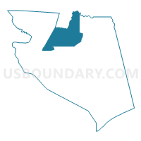
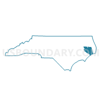
Voting District FF, Hyde County, North Carolina
About
Outline

Summary
| Unique Area Identifier | 640496 |
| Name | Voting District FF |
| County | Hyde County |
| State | North Carolina |
| Area (square miles) | 114.39 |
| Land Area (square miles) | 86.23 |
| Water Area (square miles) | 28.16 |
| % of Land Area | 75.38 |
| % of Water Area | 24.62 |
| Latitude of the Internal Point | 35.56099530 |
| Longtitude of the Internal Point | -76.21726910 |
Maps

Graphs
Select a template below for downloading or customizing gragh for Voting District FF, Hyde County, North Carolina


Neighbors
Neighoring Voting District (by Name) Neighboring Voting District on the Map
- Voting District 03, Tyrrell County, NC
- Voting District 14, Tyrrell County, NC
- Voting District BM, Hyde County, NC
- Voting District ENG, Hyde County, NC
- Voting District LL, Hyde County, NC
- Voting District SLAD, Hyde County, NC
- Voting District SQ, Hyde County, NC
Top 10 Neighboring County Subdivision (by Population) Neighboring County Subdivision on the Map
- Lake Landing township, Hyde County, NC (1,784)
- Fairfield township, Hyde County, NC (1,160)
- Currituck township, Hyde County, NC (1,129)
- Swan Quarter township, Hyde County, NC (782)
- Gum Neck township, Tyrrell County, NC (425)
- Lake Mattamuskeet UT, Hyde County, NC (7)